![](/images/other/stat-length.png)
![Randonnée Marche les Masies de Roda - Parrador Vilanova de Sau - Photo](https://media.geolcdn.com/t/1900/400/d7428330-570a-43de-975b-5e854c8c8856.jpg&format=pjpeg&maxdim=2)
Parrador Vilanova de Sau
emileverschueren
Utilisateur
![Longueur](/images/other/stat-length.png)
![Altitude max](https://static1.geolcdn.com/siteimages/upload/files/1508320355ic_sort_altitude_max_24dp.png)
![Dénivelé positif](https://static1.geolcdn.com/siteimages/upload/files/1508320355ic_sort_den_pos_24dp.png)
![Km-Effort](/images/other/stat-length.png)
![Altitude min](https://static1.geolcdn.com/siteimages/upload/files/1508320355ic_sort_altitude_min_24dp.png)
![Dénivelé négatif](https://static1.geolcdn.com/siteimages/upload/files/1508320355ic_sort_den_neg_24dp.png)
![Boucle](https://static1.geolcdn.com/siteimages/upload/files/16400158638029165_repeat_loop_refresh_sync_direction_icon.png)
![Marche](https://static1.geolcdn.com/sitytour/trail-icons/101.png)
5h13
Difficulté : Facile
![Scannez ce code QR pour ouvrir la randonnée dans l'application SityTrail](https://capi.geolives.com/qq0zvz2zws4bq2lad0pu/sitytour/trails/3428794/qr.png?size=200)
Application GPS de randonnée GRATUITE
À propos
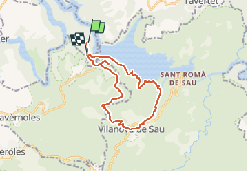
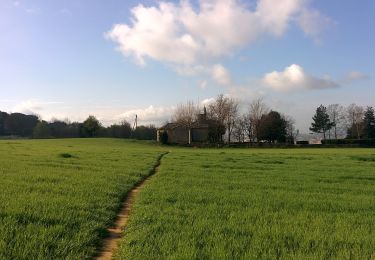
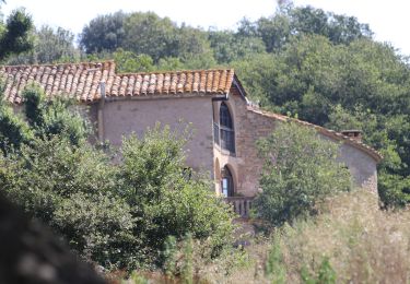
Randonnée Marche de 15,8 km à découvrir à Catalogne, Barcelone, les Masies de Roda. Cette randonnée est proposée par emileverschueren.
Description
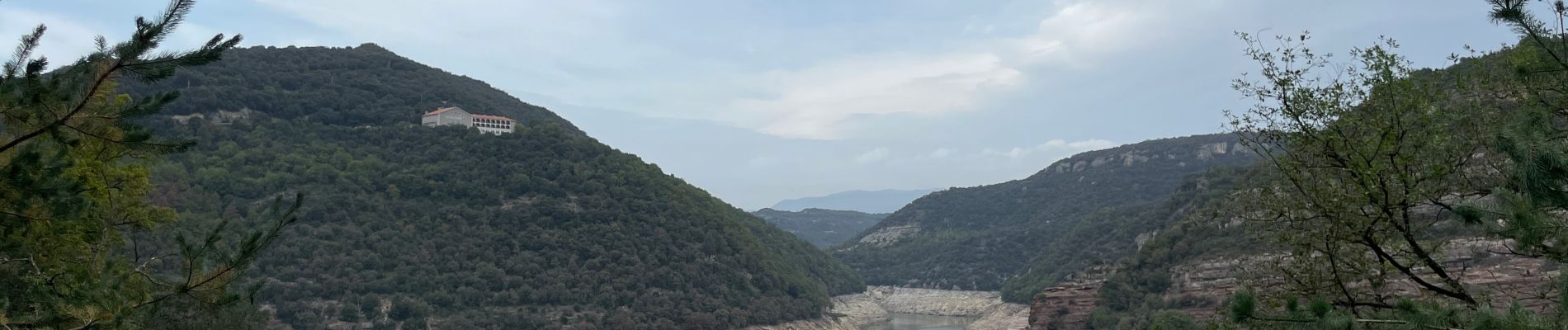
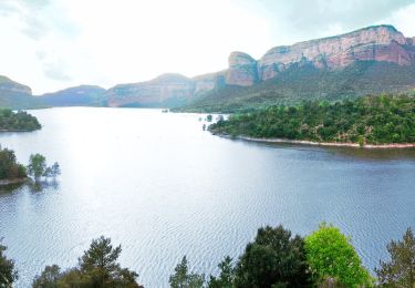
Tout l’intérêt d’une telle balade serait de pouvoir contempler et les falaises et le lac.
Nous avons fait 16 km pour ne pratiquement rien voir de ces deux points d’interêt. Merci à l’office du tourisme du coin de nous avoir conseillé un tel gâchis.
En guise de fin de parcours on se tape 5 km de béton bien dur. Les cartes IGN espagnoles ont cette particularité de confondre chemins, pistes empierrées et routes, ce qui nous vaut cette dernière étape calamiteuse.
Nonobstant l’exploit des calories, la véritable performance c’est de n’avoir fait qu’entrapercevoir lac et falaises.
Bref nous venons de perdre notre journée.
Localisation
Commentaires
Randonnées à proximité
![Randonnée A pied Vilanova de Sau - Vilanova de Sau-Rupit - Photo](https://media.geolcdn.com/t/375/260/23ad58e0-c79e-4e23-a226-ead89b99f83f.jpeg&format=jpg&maxdim=2)
![A pied A pied](https://static1.geolcdn.com/sitytour/trail-icons/100.png)
A pied
![](/images/other/stat-length.png)
![](https://static1.geolcdn.com/siteimages/upload/files/16400158638029165_repeat_loop_refresh_sync_direction_icon.png)
![Randonnée A pied Vilanova de Sau - La Riba-el Bruguer - Photo](https://media.geolcdn.com/t/375/260/23ad58e0-c79e-4e23-a226-ead89b99f83f.jpeg&format=jpg&maxdim=2)
![A pied A pied](https://static1.geolcdn.com/sitytour/trail-icons/100.png)
A pied
![](/images/other/stat-length.png)
![](https://static1.geolcdn.com/siteimages/upload/files/16400158638029165_repeat_loop_refresh_sync_direction_icon.png)
![Randonnée A pied Tavèrnoles - Folgueroles-Salt de la Minyona-Tavèrnoles - Photo](https://media.geolcdn.com/t/375/260/23ad58e0-c79e-4e23-a226-ead89b99f83f.jpeg&format=jpg&maxdim=2)
![A pied A pied](https://static1.geolcdn.com/sitytour/trail-icons/100.png)
A pied
![](/images/other/stat-length.png)
![](https://static1.geolcdn.com/siteimages/upload/files/16400158638029165_repeat_loop_refresh_sync_direction_icon.png)
![Randonnée A pied Folgueroles - Folgueroles-Monòlits de Jacint Verdaguer - Photo](https://media.geolcdn.com/t/375/260/554d4686-3e9e-4283-ad21-015d9b206eb9.jpeg&format=jpg&maxdim=2)
![A pied A pied](https://static1.geolcdn.com/sitytour/trail-icons/100.png)
A pied
![](/images/other/stat-length.png)
![](https://static1.geolcdn.com/siteimages/upload/files/16400158638029165_repeat_loop_refresh_sync_direction_icon.png)
![Randonnée A pied Folgueroles - Folgueroles-Sant Jordi de Puigseslloses - Photo](https://media.geolcdn.com/t/375/260/b5278c79-40c6-48e7-8f1a-b9838b7ebb51.jpeg&format=jpg&maxdim=2)
![A pied A pied](https://static1.geolcdn.com/sitytour/trail-icons/100.png)
A pied
![](/images/other/stat-length.png)
![](https://static1.geolcdn.com/siteimages/upload/files/16400158638029165_repeat_loop_refresh_sync_direction_icon.png)
![Randonnée A pied Folgueroles - Camins de Verdaguer - Photo](https://media.geolcdn.com/t/375/260/faa70fe2-3923-4f22-beb8-d6b977e9c34e.jpeg&format=jpg&maxdim=2)
![A pied A pied](https://static1.geolcdn.com/sitytour/trail-icons/100.png)
A pied
![](/images/other/stat-length.png)
![](https://static1.geolcdn.com/siteimages/upload/files/16400158638029165_repeat_loop_refresh_sync_direction_icon.png)
![Randonnée A pied Folgueroles - SL-C 123 Folgueroles - Photo](https://media.geolcdn.com/t/375/260/1a1ef6c9-8443-4e4f-8730-e4fa7346065b.jpeg&format=jpg&maxdim=2)
![A pied A pied](https://static1.geolcdn.com/sitytour/trail-icons/100.png)
A pied
![](/images/other/stat-length.png)
![](https://static1.geolcdn.com/siteimages/upload/files/16400158638029165_repeat_loop_refresh_sync_direction_icon.png)
![Randonnée A pied Vilanova de Sau - SL-C 122 Vilanova de Sau-Puig del Far - Photo](https://media.geolcdn.com/t/375/260/bf4ff840-bccb-4eba-8bff-6acf6708a69a.jpeg&format=jpg&maxdim=2)
![A pied A pied](https://static1.geolcdn.com/sitytour/trail-icons/100.png)
A pied
![](/images/other/stat-length.png)
![](https://static1.geolcdn.com/siteimages/upload/files/16400158638029165_repeat_loop_refresh_sync_direction_icon.png)
![Randonnée A pied Vilanova de Sau - Pont de Malafogassa - Photo](https://media.geolcdn.com/t/375/260/9a6a3c9a-25f5-40a1-9585-400ad774ba8c.jpeg&format=jpg&maxdim=2)
![A pied A pied](https://static1.geolcdn.com/sitytour/trail-icons/100.png)
A pied
![](/images/other/stat-length.png)
![](https://static1.geolcdn.com/siteimages/upload/files/16400158638029165_repeat_loop_refresh_sync_direction_icon.png)